XDS: MTSAT
mtsat: Multi-Functional Transport Satellite
General Data Description
The Multi-functional Transport Satellite (MTSAT) series fulfills two functions: a meteorological function by the Japan Meteorological Agency and an aviation control function by for the Civil Aviation Bureau of the Ministry of Land, Infrastructure and Transport. The MTSAT series succeeds the Geostationary Meteorological Satellite (GMS) series as the next-generation geostationary satellite series covering the East Asia and the Western Pacific regions.
Measurement Description
The measurements in these data files are similar to those in the GMS-5 data files. The visible channel data are averaged over a 5-by-5 km grid cell.
Up to 2006-04-26 the data supplied to ARM included only the “GMS-5” look-a-like product with 4 channels and 8-bit digital resolution. As of 2006-04-26, all 5 channels at their full 10-bit digital resolution are included in the ARM archived datastreams. The extra IR channel (IR4) covers wavelengths 3.5-4.0 um.
The detailed spectral response functions for all 5 channels are given by the Japanese Meteorological Satellite Center
Temporal Coverage
TWP Data begin 2005-07-14.
HFE data are only available for calendar year 2008, when AMF1 was deployed in China.
Area Covered
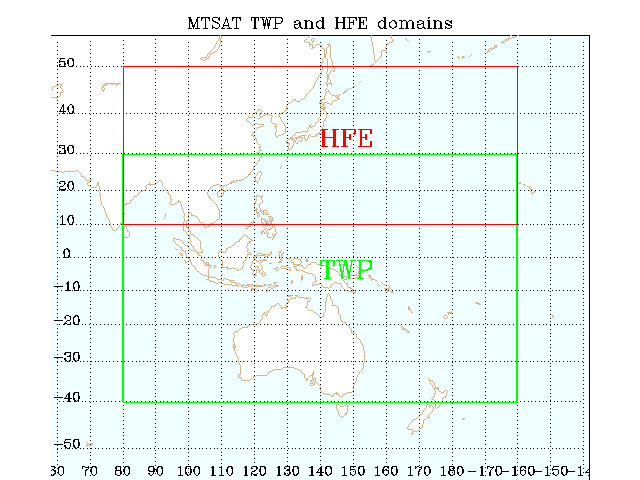
TWP
Longitude: 80° N to 200° E
Latitude: 40° S to 30° N
HFE (2008 only)
Longitude: 80° E to 200° E
Latitude: 10° N to 50° N

Datastream Inputs
twpmtsatX1.00
Related Links
MTSAT Technical Information from the Australian Bureau of Meteorology
PDF Document on 14th Conference on Satellite Meteorology and Oceanography from NOAA Website
Contacts
ARM Data Center
Data Source
Institution
From: Japan Meteorological Agency (JMA)
Outline of the Multi-Functional Transport Satellite (MTSAT) series
Data collected by SeaSpace Corporation
Processing History
2005-07-14 to 2006-04-26
GMS-5 look-a-like product with just the 4 GMS-5 equivalent channels
Since 2006-04-26
All 5 channels including IR4 (3.5 to 4 um)
FAQ
Q: The MTSAT hdf files (twpmtsatX1.a1.*hdf) contain time information for each pixel in the ‘time’ field. What exactly does this time correspond to? Is it in seconds calculated from some reference time?
A: The units ‘stdtime’ refers to seconds since midnight UTC. Remember to apply HDF scale_factor and add_offset first:
time = (filevartime-add_offset) * scale_factor
Data User Notes
In order to avoid damage to the visible channel detector by accidentally pointing straight at the sun, the scanner is reprogrammed to avoid the Earth view around midnight sub-spacecraft local-time during the eclipse season.
The visible channel may contain non-physical data during the 13:30Z, 14:30, and 15:30Z observations in this time period.
Start Date: 20060808
End Date: 20061106
Quicklook Links
TWP MTSAT Composite
<!–a href=”http://www.xdc.arm.gov/data_viewers/hfemtsat_composite/frameset.html”>HFE MTSAT Composite (2008 only)
Acronyms
JMA    Japan Meteorological Agency
MSC    Japanese Meteorological Satellite Center
MTSAT  Multi-functional Transport Satellite
GMS    Geostationary Meteorological Satellite

