KAZR-ARSCL and KAZRCOR Products Now Available for 2011-2014 Data
Published: 16 November 2016

Updated 3/1/2017: Data has been updated from evaluation data to baseline production data.
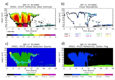
The Active Remote Sensing of Clouds product using Ka-band ARM Zenith Radars (KAZR-ARSCL) value-added product (VAP) and KAZR Corrected Data (KAZRCOR) VAP together are successors to the retired ARSCL VAP.
The ARSCL VAP was based on the
Millimeter Wavelength Cloud Radar (MMCR), ARM’s original vertically pointing cloud radar. ARSCL processing optimized MMCR reflectivities and mean Doppler velocities and merged radar modes to provide best-estimate radar moments. The ARSCL VAP also combined corrected radar reflectivity with micropulse lidar and ceilometer observations to determine cloud boundaries.
The new KAZRCOR and KAZR-ARSCL VAPs were developed for the same purposes, using the KAZRs, which are the upgraded radars that replaced the MMCRs. The KAZRCOR VAP provides corrections to KAZR moments for each radar mode (the general mode, ‘ge’, and whichever higher-sensitivity mode was operating, either the medium-sensitivity, ‘md,’ or high-sensitivity, ‘hi,’ mode). The VAP corrects calibrated reflectivity for gaseous attenuation and dealiases mean Doppler velocities.
In addition, a significant detection mask is created for each radar mode. Two corrected KAZR datastreams are produced at each site: ‘kazrcorge’ and either ‘kazrcormd’ or ‘kazrcorhi.’ The new KAZR-ARSCL VAP uses the ‘kazrcor’ datastreams as input, along with micropulse-lidar-derived cloud mask and cloud base, ceilometer-derived lowest cloud base, microwave radiometer liquid water path, and rain gauge observations to produce cloud boundaries and corrected, best-operating-mode radar moments on a time-height grid.
An automated algorithm is used to flag radar clutter and remove it from the reported ‘best-estimate’ reflectivity field. The KAZR-ARSCL output grid has 4-second time resolution and 30-m spacing in height.
Two KAZR-ARSCL datastreams are produced:
- arsclkazr1kollias: Best-estimate radar moments and hydrometeor boundaries
- arsclkazrbnd1kollias: Best-estimate cloud base and hydrometeor-layer boundaries.
Previously, KAZR-ARSCL and KAZRCOR data were available for limited time periods, but are now available for all time periods for which calibrated data have been produced, as follows:
- NSA-C1: 2011.11.11 – 2014.02.07
- SGP-C1: 2011.01.18 – 2014.03.15
- TWP-C1: 2011.03.12 – 2013.12.03; 2014.02.01 – 2014.05.03
- TWP-C3: 2011.01.27 – 2014.05.03
- GAN-M1: 2011.10.09 – 2012.02.07
To access the data sets, please browse KAZR-ARSCL and KAZRCOR at the ARM Data Archive. (Go here to create an account to download the data.)
# # #
The ARM Climate Research Facility is a national scientific user facility funded through the U.S. Department of Energy’s Office of Science. The ARM Facility is operated by nine Department of Energy national laboratories.
The ARM Climate Research Facility is a DOE Office of Science user facility. The ARM Facility is operated by nine DOE national laboratories, including .
Keep up with the Atmospheric Observer
Updates on ARM news, events, and opportunities delivered to your inbox
ARM User Profile
ARM welcomes users from all institutions and nations. A free ARM user account is needed to access ARM data.


