ARM Cloud Retrieval Ensemble Data Set Available for Evaluation
Published: 31 August 2011

A new ARM evaluation product, the ARM Cloud Retrieval Ensemble Data Set (ACRED), is now available for testing by the science community. ACRED was developed with the motivation to provide a rough estimate of the uncertainties in current retrieved cloud microphysical properties for climate model evaluation and development. It was created by assembling numerous existing ground-based cloud retrievals together for the ARM Facility’s permanent research sites at the Southern Great Plains (SGP), North Slope of Alaska (NSA), and Tropical Western Pacific (TWP).
The current ACRED data set contains measurements of:
- Cloud liquid effective radius, liquid water content, and liquid water path
- Cloud ice effective radius, ice water content, and ice water path
- Cloud liquid optical depth and ice optical depth at solar wavelength
- Cloud fraction
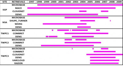
To facilitate use by climate modelers, the quantities in ACRED are averaged hourly with a vertical resolution of 45 meters, consistent with the temporal and vertical resolutions in the ARM Climate Modeling Best Estimate (CMBE) value-added product. ACRED contains three to six retrieval products for the following ARM sites and dates:
- SGP.C1 (Lamont, OK) 1999–2008
- NSA.C1 (Barrow, AK) 1997–2008
- TWP.C1 (Manus Island) 1999–2007
- TWP.C2 (Nauru) 1998–2006
- TWP.C3 (Darwin, AU) 2003 and 2005–2009.
To access the ensemble data set, log into the ARM Data Archive .
Please contact relevant PIs for more information or for assistance in interpreting their data, and provide feedback on the data set to Shaocheng Xie. Feedback obtained during this 6-month evaluation period will be used to improve ACRED and guide development of future cloud data products.
The ARM Climate Research Facility is a DOE Office of Science user facility. The ARM Facility is operated by nine DOE national laboratories, including .
Keep up with the Atmospheric Observer
Updates on ARM news, events, and opportunities delivered to your inbox
ARM User Profile
ARM welcomes users from all institutions and nations. A free ARM user account is needed to access ARM data.


